
Cody Perry is a filmmaker and conservationist who has spent an untold number of hours living, breathing, rafting and documenting the waterways and ecosystems that are tied to the rivers of northeast Utah and northwest Colorado for his company Rig To Flip. He’s a man who knows the people, animals and land of that area in a very intimate and personal way.
He’s currently trying to raise the alarm about prospective drilling operations that threaten the environmental and economical interests of the Uinta Basin in Utah, with some prospective leases less than a mile from the western border from Dinosaur National Monument, one of the most unique and oldest national park units in the nation. By his account, these drilling operations are speculative rolls of the dice that are expensive, time consuming and inefficient for the oil and gas energy they would attempt to bring to market, with guaranteed negative effects to the air quality, water quality and renewable economies in tourism and agriculture that the people in the area rely on.
As of now there is a current 30-day period in which the Bureau of Land Management (BLM) must accept comments and concerns from the public, which can be accessed here. After reading my conversation with Perry below please consider participating and in the public forum and making your voice heard.

The following is a conversation with Cody Perry. It has been edited for length and clarity.
What do you see as the overall issue that is pressing?
There’s this company that has applied to drill this exploratory oil well with a contingency well as well. It’s one that’s to see if there is oil there and another one just in case it is dry. These are in existing lease areas. One of the biggest issues is not just the drilling itself but access to the drill sites, it would include grading an existing two-track road. It would improve this three miles of road that runs along a gas line adjacent to Dinosaur National Monument. We’re talking about it being a big 14-foot road that would be used to bring in a truck-mounted drill rig. We’ve looked at the designs and they are concerning, like if a big rain storm showed up.
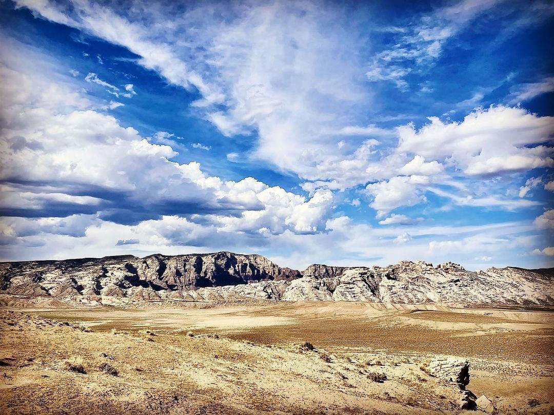
There’s the exploratory drilling and the construction of new roads and all of this is happening less than half a mile from the western boundary of Dinosaur, a national park unit. 2,000 feet is less than a fifteen minute walk. This isn’t just any park unit, Dinosaur National Monument has a special significance in the American lexicon of wilderness. It has a unique history that led to the formation of the Wilderness Act and set precedent that you can’t just dam a national park unit from inside. It tested the very purpose of the national park service in that it’s centered around preservation and it had this important contribution to how we operate national parks and why we set land aside for purposes that are kind of intangible.
They’re rolling the dice essentially: it’s for an unproven oil well, up against a national park unit, and taking this tiny, little modest road and turning it into something that an RV can drive up. Those are the threats.
Can you talk about how the ozone might be impacted in Dinosaur and the surrounding area?
The Uinta Basin and the communities of Vernal and Jensen and Roosevelt and Fort Duchesne are sitting on the world’s largest known oil shale deposit; one-third of the world’s known deposits are in the basin. It’s a hot spot for energy, though not just any energy because it has special properties. Traditionally it is accessed by drilling a hole in the ground, they activate the well and fluids come up periodically along with other bio byproducts, one of which in the basin is a ton of water that comes up with these hydrocarbons. You can’t drink it and it’s totally unusable in terms of human consumption.
The other byproduct is natural gas and if you kind of don’t capture it right away you flare it off. When you have these gas emissions that aren’t being brought to market this stuff gets up into the air and affects air quality. It can be particulate matter or it can be this thing called ozone, which is this unique kind of thing that comes with gases that are emitted out of these oil and gas infrastructures, which cumulatively pools up in the winter time and sits on top of the ground.
What makes it really volatile is when sunlight comes down — especially with snow on the ground —- and there is this refraction of sunlight that activates and changes the nature of these gases to produce ozone. Ozone is extremely harmful to the environment and human health. What happens in the Uinta Basin during wintertime are these seasonal inversions that overlay and disproportionately impact the Uinta and Ouray Ute reservation lands and communities and descend over these areas. It’s very harmful and exceeds federal health standards and extends into the Monument.

I was reading in the Salt Lake Tribune about these moratoriums placed on these drilling leases by the Biden administration. In one of the articles, according to Steve Bloch, the legal director of Southern Utah Wilderness Alliance, “In Utah alone, the industry is sitting on 1.7 million acres of unused leases.” It’s wild to think they’d still be looking for more leases.
The narrative right now from the oil and gas industries revolve around the negative impacts a moratorium on further leases on public land for the purposes of energy development. What we are seeing though is an increase in production at the moment on existing leases that are already in the portfolio of these companies and industry at large. There’s approximately 16 million acres of active leases that are currently held out of roughly 26 million acres of public land the industry has access to. We’re talking major land acquisitions of a public asset for the purpose of a private industry. BLM has been bending over backward to accommodate these leases.
A parcel that is leased to a company has a 10-year lifespan upon primary development. After that 10 years the company usually has to go through a reconciliation process. Ideally after 10 years the company has realized the lifespan of the well and has reclaimed the site and plugged the well. Does that happen? It’s a little worse than 50-50. There’s a significant amount of oil wells that are out on the land where the original company that invested in drilling the hole is no longer a company anymore.
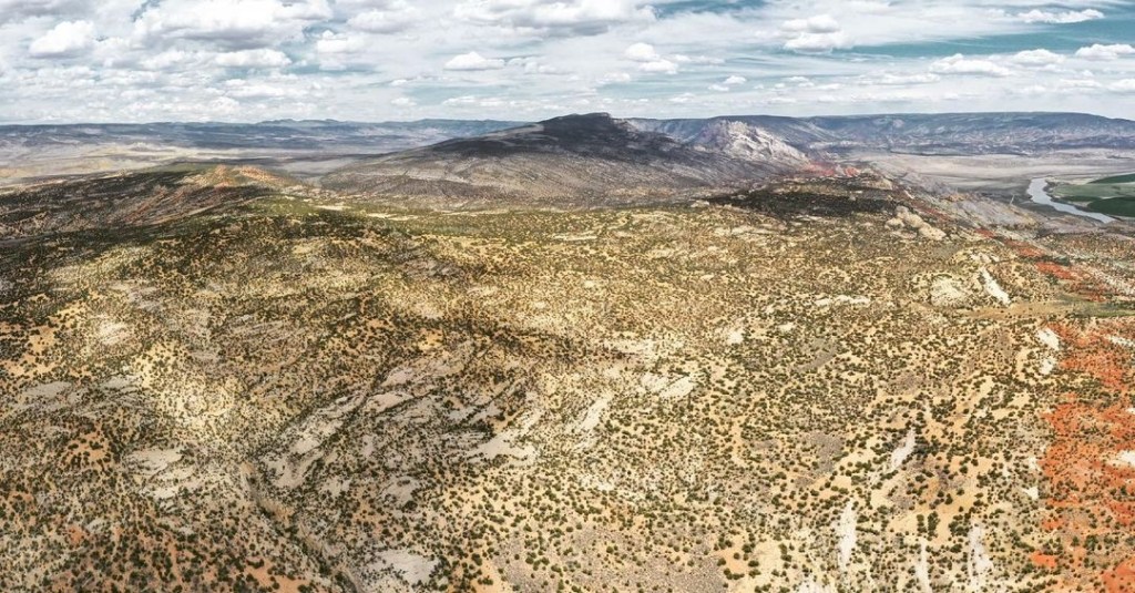
To bring it back into the ones by Dinosaur, I describe it as a rough delineation that comes to northeast Utah and Dinosaur National Monument that can be drawn along U.S. Highway 40. What’s north of that line is tons of open space and tribal lands and agricultural lands and energy development. It’s by and large National Forest, BLM and Dinosaur. On the south side the vast majority is energy development where the payout has been more historically represented by somewhere in the realm of 30,000 oil wells. They are spread throughout that zone and tribes are an energy producer and most of the operators are big money operations. Most of the outfits can’t afford the type of investment it takes to get oil and gas from this zone. You need really specialized equipment.
The type of oil in this area has a really high paraffin content and if you were to drill it and pump it out and put into a cup it would solidify into this very waxy material like a candle. To transport it you need to actually heat this up to 100 degrees Fahrenheit and you can’t really pipe this stuff, the whole line needs to be heated and insulated. It’s extraordinarily expensive to bring this stuff to market and in the big picture it is a very small amount of energy. Utah produces a fraction of what Wyoming and the Dakotas produce. We are squeezing the driest lemon and these oil wells next to a national monument are extremely inappropriate.
Add in this dichotomy between what you would expect from these indigenous communities and the Mormon white or Utah proletariat that exists there, there is a binary nature between these two that exist there. There’s a big part of the community that looks to the lands north of 40 as a sustainable and recreational tourist-like economy and the south is the energy economy and there’s a balancing act to perform between the two. Developing oil north of that line diminishes the return on what is more sustainable for a group of people and sector of society in wildlife and agriculture that depend on those sustainable economies. This development is an encroachment on the return of those economies.
It really makes you scratch your head as to why is this wise land use planning?
For people that might find resonance on this issue, how can they act on that resonance and concern for what’s going on?
What you can do is participate in a 30-day public comment period and the BLM is required to take all comments from participating members of the public. If you have a computer or library or phone you can participate and let your voice be known to the deciding agency about what your concerns are. There is a portal online for the public to participate in and they are required to read your comment.
What’s great is that the agency does this in one way because they don’t assume they’ve thought about everything. They open it to the public in a way that I like to think of that they are trying to consider things they might have missed. Quite often those things are brought to their attention by members of the public or organizations that are acting on the behalf of the public’s interest.
